Friday, July 12, 2013

Hay siempre un lugar en mi corazon para Sud America

      Due to a shortage of funds, I had to cut my travels one month short. I was sad to go and really bummed to miss out on Ecuador and Colombia, especially since we were supposed to meet up with friends there. I don't think I have ever NOT wanted to go back to the U.S. so much. I just wanted to lay down on the ground and hold on to Peru and never let go. Nonetheless, the past two months I've spent traveling have been the most worthwhile and inspiring adventure.

     My last few days in Peru were spent in Lima. When I first came to Peru I arrived in Lima and spent a night and a morning there. I wasn't impressed. It looked like an ugly, dirty city. Most travelers I've met don't like Lima either. It's one of those places where it's best to know someone who actually lives there that you can stay with and who can show you where to have a good time. The good thing about having low expectations is that you can be easily impressed. I actually had a good time in Lima. It's not the most interesting place historically or culturally, but I went to some nice areas.

      We stayed in the neighborhood, Miraflores. Miraflores is the nicest and safest neighborhood for tourists to stay. It is a very wealthy neighborhood and also very commercial. From Miraflores we could walk to the beach. It's honestly not the nicest beach but there was a very fancy mall built overlooking it. Considering how fancy that mall was, it was funny to see a TGI Fridays and Chili's restaurant there. The best part about Miraflores is the sandwich restaurant, La Lucha, which Mallory had been raving about since we arrived in Peru. They truly serve delicious sandwiches and fries. We also checked out the historical center and walked around looking at the historical and government buildings.

Standard protest at the Plaza de Armas

Plaza Mayor

Presidential Palace

      One day we ventured out to the next neighborhood, Barranco. It was nice to walk along the beach to get there. The first thing we did was go to the Museo de Arte Contemporanea (MAC), which we happened to stumble upon on our way. It was a really cool museum and we lucked out because that day the entrance fee was only 2 soles. I liked Barranco a lot. It was more my vibe. It was still nice and safe, but it was more bohemian and far less commercial than Miraflores. There is this cool spot by "the puente" lined with restaurants and a view of the ocean. This is where I ate the best ceviche I've ever had. I give Lima props for that.

The MAC

Barranco

View from our table at Javier's in Barranco

     On my last night in Peru, I went out with a traveler I met in Arequipa and her local friends. It was so nice to spend my last night in good company and to get to have my last conversations in Spanish. I even got to try a Peruvian drink I've never had before. I think it's called "elementario" and it is a hot alcoholic cocktail. It was nothing like I've ever drank before, but good. And boy was it strong! Of course my last night in a hostel couldn't go without a weird experience. Our dorm-mates arrived later than we did and really loudly, stumbling around the room in the dark. One of them, some drunk dude, thinking it was his bed, tried to get into my bed...twice! I was just conscious and sober enough to half-ass elbow him until he left, and then again the second time. Oh, 12-bed hostel dorm rooms. Of the many times I've spent a night in a big dorm room, that was the first time that has ever happened.

     Having arrived in Lima and then departing in Lima, I guess Mallory and I made it full circle. On June 27th in the evening we packed up our big backpacks one last time and hauled them into the taxi to the Lima international airport. I was not ready to leave yet. The decision to go home early and change my flight was a really sudden move. I was not mentally prepared to leave South America. In that long taxi ride against the rush hour traffic, it was like a montage was playing in my head of everything I love and will miss about South America. Firstly, I miss all the people that I grew to love and share my experiences with, especially the ladies that took care of me in my volunteer house in Cusco (Juliana, Yuliet, Rocio, Nelli, and Yonni). I miss my kids at the hospital I volunteered at. I miss speaking and hearing Spanish all the time. I miss salsa dancing. I miss Peruvian food and all of its salsas, particularly chimichurri. I miss Cusco and the Andes mountains and the Valle Sagrada. I miss walking everywhere. I miss the "time warp" of "traveler's time", in which you become practically BFF's with the people you spend adventuring with over a span of just a couple days. I miss seeing cholita mamas and their adorable babies. I miss being called "Carita" and "mami or mamita". I miss the sense of community in Peruvian culture and how everyone takes care of each other. I miss Peruvians' big, beautiful smiles :-D

I feel like my soul has been rejuvenated these past eight months in South America. Entonces, hay siempre un lugar en mi corazon para Sud America. Voy a regressar.

(There is always a place in my heart for South America. I will return)

Travel tips:
Hostel: Pariwana-Lima 27 soles per night in 12-bed dorm
Restaurants: La Lucha in Mira Flores, Javier's in Barranco
Museum: MAC (Museo de arte contemporanea) 2 soles on Thursdays
Bus from Arequipa to Lima: Oltursa 80 soles

Sunday, July 7, 2013

Our final trek

       From La Paz, Bolivia we made our way back to our South American motherland, Peru. It was so good to be back on Peruvian soil. I just love this country so much. This time adventure awaited us in Arequipa, most famous for being the gateway to the Colca Canyon. Arequipa is known as "la ciudad blanca" (the white city) because many of its colonial buildings are made of sillar, which are bricks made of compacted volcanic ash. Hence, these buildings are white. Why volcanic ash? Because Arequipa is surrounded by volcanoes. The nearest one being Volcan Misti, which stands in the background of the city.

Peruvian-Bolivian border. I <3 Peru

Arequipa's Plaza de Armas with the snow-capped peak of
Volcan Misti in the background

La Ciudad Blanca

       My main goal in the city of Arequipa was to see Juanita, the ice mummy. Each time my friends went to Arequipa in the past, she was not at her home display case in the Museo Sanctuarios Andinos. I heard rumors that she'd be back on exhibit in June. I was so excited when we entered the museum to discover that she was back on exhibit. "Juanita" was discovered by archaeologist and mountaineer, Dr. Johan Reinhard, after whom she was named, on the summit of Volcan Ampato at 6, 380 m elevation. In fact, she was found perfectly preserved in ice, exposed in the open snow. Two weeks prior, a nearby volcano had erupted and the resulting earthquakes ejected her out of her burial site and out into open air. What luck that Dr. Johan Reinhard stumbled upon her just two weeks later!

A postcard I got at the museum. Taking photos is prohibited.

        Juanita was a chosen child from Cusco to be sacrificed to the gods (the mountains) to appease them and ensure the Incan People's safety and prosperity. There had been volcanic eruptions, which the Incas believed were expressions of the gods' anger. The "chosen" children were of nobility, educated and pure. Only the creme of the crop were chosen to be human sacrifices. Thanks to carbon dating and the perfectly preserved state of her body, Juanita was about 12 to 14 years old when she was chosen to be sacrificed. The chosen children were raised to believe that it was an honor to be sacrificed to the gods and that they themselves would join the gods in the afterlife. With her shaman entourage, Juanita trekked from Cusco to Arequipa and ascended up to the summit of Volcan Ampato, where she was given sedatives and then killed by blunt force to the head. Up at the summit she was buried with ceramic and gold offerings.

       My other goal in Arequipa was to do the free walking tour, which I didn't know existed until seeing its business card/coasters at our hostel. It is run by the same company that does the free walking tour we did in Cusco way back in November. It's appropriately called, Free Walking Tour Arequipa. We even had the same guide we had in our Cusco tour. These tours were both more commercial than historical, but nonetheless informative and enjoyable. It was mostly about showing tourists where they should go hang out in Arequipa outside of the main Plaza de Armas. I did learn a few interesting tidbits about Arequipa. For example, The original name of the city in Quechua was two words: "Ara" - "Quipay", which means "stay here". Later the Spaniards screwed up the pronunciation and the city was named "Arequipa". At least it wasn't too far off. My favorite part of the tour was going to the alpaca/llama farm and wool factory. We got to feed the llamas! We also learned about the difference in the quality of llama, alpaca, and vicuna wool. Firstly, "baby alpaca" is the best quality of alpaca wool. However it is not wool from an actual baby alpaca. After all, if you shave a baby alpaca it will die from exposure in the cold Andes highlands. "Baby alpaca" is actually the wool from the very first time a grown alpaca is sheared. Every time the alpaca is sheared afterwards, the quality of its wool decreases. Llama wool is used for more durable things. It's not soft enough to be used for clothing. The highest quality wool is from vicuna. Vicuna is a smaller cousin of the llama and alpaca. It is also a wild animal, not domesticated. There is a cap on how many vicuna can be hunted for its wool. Vicuna wool is so expensive that its value is equal to the value of gold!

Alpaca!

The 30 natural colors of alpaca wool

Vicuna wool. Feels like touching a cloud!

Weaving alpaca yarn on a loom attached to her waist

      Our main goal for the Arequipa area was to trek the Colca Canyon. Our final trek in South America :-(   Good thing it was only a 2 day trek and easier compared to other treks in Peru because I was definitely out of high altitude trekking shape by this point in our travels. We were picked up by our tour agency's bus at 3:30am and drove 3 hours to the top of the Colca Canyon. Here we stopped at the Cruz del Condor where we took photos of the canyon from up high and of the condors soaring through the canyon.


Cruz del Condor

Condor

       Then we started our trek. Day 1 was all descent, deep down to the bottom of the canyon. According to National Geographic, the Colca Canyon is the deepest canyon in the world. It is more than twice as deep as the Grand Canyon in the United States with a depth of just over 4, 000 m. It is arguable that Cotahuasi Canyon, the other canyon just outside of Arequipa (which is far less popular for some reason I don't know), may in fact be deeper.

The beginning of the descent into the Colca Canyon

A look down to our oasis goal

Cool rock face

       At the end of our descent, we arrived at "the oasis" at about 5 pm where we would be spending the night. The oasis even had a pool fed from the water from the river that cuts through the canyon. Most of us in our trek group got in. It would have been nicer if it wasn't winter and the warmth from the sun was still shining over us at that hour. Oh well. I'm sure it was therapeutic for our muscles anyways.

Nearing the oasis at the bottom of the canyon

       Early the next morning we started trekking back up the canyon at 5:30 am. Our guide said it was a 3 hour trek up to the top. The guys in our group made it their goal to reach the top by 2 hours. They accomplished their goal at exactly 2 hours. Well done, boys! I reached the top after them at 2 hours and 20 minutes. Eventually we regrouped with everyone as they all trickled up the trail. After regrouping we walked for 15 minutes over "Peruvian flat" (a term said by our guide as he made wavelike up and down motions with his hand, which is hilarious because the description is so true. As I've learned in my previous treks in Peru, "flat" does NOT exist) to the nearest town, Cabanaconde, for a well deserved breakfast.

View of the ascent trail from the oasis

Our group back at the top of the canyon. 

       Afterwards we stopped by a tiny town where we could check out the artisan markets and try a "Colca Sour", like a Pisco Sour but made with juice from prickly pears (cactus fruit) instead of limes. It was very tangy, but that's just how I like my fruits and Pisco coctails. Then we drove to the highest point of our trip to a vista where you could see all of the surrounding volcanoes, including Volcan Misti and Volcan Ampato. We stood at 4, 810 m above sea level and it was cold. Finally we made it to the town of Chivay where we got to soak our very sore muscles after climbing down and up that very steep canyon in the thermal baths. Thermal baths are a big plus to traveling along volcanic areas. I couldn't believe how sore my leg muscles were after that Colca Canyon trek. It was only for two days and it wasn't nearly as hard or as long as Choquequirao or the Inca Jungle trek. Nonetheless it was well worth it and we had a fantastic group. It was the best final trek I could have asked for.

Travel tips:
Bus from La Paz to Arequipa (stops in Copacabana and Puno) with Titicaca bus tours - 200 Bolivianos
Hostel in Arequipa: Wild Rover Hostel for 25 soles per person in 6 bed dorm (do not stay here if you want to be able to sleep at night)
Free Walking Tour Arequipa: meets Monday-Saturday at Plaza de San Francisco at 11:50 am
2 day Colca Canyon trek: Andina tours 110 soles
Juanita: Museo Sanctuarios Andinos -entrance 20 soles plus tip for the museum guide who takes you to see Juanita
Bar scene: Retro bar for live rock cover bands and really good pisco sours

Monday, July 1, 2013

Nice try, Death Road. Nice try.

      Another cold night bus later, we reached La Paz. I had not heard that much about La Paz from other travelers. Nothing particularly good or bad, so I didn't really know what to expect. Driving into La Paz that morning reminded me of Cusco. Like Cusco, the city of La Paz sits in a bowl up high in the Andes mountains. As our bus circled further down into the center of the bowl, I realized that unlike Cusco, La Paz is not only higher in elevation, but also huge. The urban sprawl reaches up high into the hills above the bowl. A friend once told me that at the rate Cusco's population is growing, it will look like La Paz with houses way up in the hills in 20 years. Also unlike Cusco, La Paz is surprisingly clean and has a very commercial-looking city center with high rise buildings. It was very nostalgic to see the familiar sight of native-dressed women walking around the city in their big, colorful dresses in La Paz, just as they did in Cusco. Since Evo Morales's presidency, the native people have taken back their place in La Paz and you see colorfully dressed natives walking alongside people in business suits. 

       That afternoon we caught the 3pm walking tour through La Paz Free Tours at the Plaza de San Francisco. At the plaza there is a very interesting mural. The shoe-shine boys in La Paz wear ski masks to cover their faces. At first I thought it was to protect themselves from the car pollution and the smell of the shoe polish. Our guides clarified that they cover their faces because they are ashamed of their jobs because it is considered low-class. It may sound ironic, but they painted their mural to show their pride and their sense community.


       La Paz is a juxtaposition of Spanish, Bolivian, and modern commercial infrastructure. Part of the city is built in a grid by the Spanish, while other parts of the city have winding roads and are not in a grid (built by the Bolivians), and the commercial center has modern high rise buildings. La Paz was the first city in South America to win its independence from Spain, even before the rest of Bolivia. Why? the Bolivianos used the war tactic of blockading the top of the bowl where the city sits to cut the city off and starve the Spaniards until they surrendered. It was a very effective strategy. They still use this strategy when there is a big revolt and it still works. 

Presidential palace

      At the Plaza de Armas next to the Presidential Palace we saw soldiers guarding a memorial for Los Disparacidos (the people who "disappeared" during the military dictatorship of the late 1970s-1980s). To this day, the Ministry of Justice will not release information about Los Disparacidos, so there is not even an estimate of how many people "disappeared." 

Memorial

       The most interesting building we saw, right in the center of downtown in front of the beautiful Plaza de San Pedro, was San Pedro Prison. It was the most unique prison I have ever seen or heard of, and it is no ordinary prison. In fact, you can't really tell it is a prison. It looks like any other official building with police guards. San Pedro is famous because it is run like a micro-city with its own micro-economy. Bolivia is a very poor country so there are no state funds to provide for the inmates. Inmates have to pay an entrance fee and have to buy their own cells. Within the walls, prisoners own shops, restaurants, etc. and even work for each other in order to make money to buy their own food and pay for their homes. These "cells" range from tiny cramped spaces shared by five people if you are very poor to penthouse apartments with jacuzzi's and big screen televisions. Basically, if you're rich and come into San Pedro Prison with money, you're set and can live in luxury inside. Many prisoners' families live with them inside the prison! A few years ago, San Pedro Prison was a very popular tourist destination. You could do a tour, and if you paid enough you could even spend the night! These tours were started by an English inmate named Thomas MacFadden. He was arrested for cocaine trafficking. Now he is one of the wealthiest prisoners in San Pedro. The book, Marching Powder is about his story. You can't do tours anymore, supposedly. San Pedro Prison is also infamous for the production and trafficking of the best cocaine in Bolivia (Yes, the inmates produce and sell cocaine within the prison walls) and for corruption of the police force. 

San Pedro Prison. 
(Doesn't look like a prison, right?!)

      Another interesting spot we saw was the mercado de brujas, or Witches Market, where you can buy your standard llama fetus and Incan trinkets for luck and blessings. Although Bolivia is a very Catholic society, most Bolivianos still practice pagan Incan traditions and rituals. The most common one is the worship of Pachamama (mother earth), which is not too far off from the worship of the Virgin Mary in Latin American culture. For example, construction workers today still will not build a building unless the proper offerings (llama fetus, blood, coca leaves, etc.) have been made to Pachamama and buried in the foundation. 

Witches Market. 
Come get your llama fetus!

      We ended the walking tour on top of a hill with a 360 degree panoramic view of La Paz. In the distance you can see the snow-capped Volcan Illimani, a dormant volcano. I forgot the name of this hill, but the locals refer to it as the "love nest" because many couples canoodle up there. 

View of Volcan Illimani from the "love nest"

       The following day we woke up early to face another adventure. The one adventure in South America that I had been nervously anticipating: mountain biking down the World's Most Dangerous Road, also fondly known as Death Road. We booked the trip through Gravity Assisted Mountain Biking, the first company that started this trip, and the most legitimate (also the most expensive). From downtown La Paz we had a 1 hour bus ride to the top of Death Road at just above 4,000 m in elevation and with snowy mountains all around us. 

Our first stop at the very beginning of the road

       The very beginning of the 4-5 hour downhill bike ride was on nice, paved two-way highway that lazily wound through these snowy mountains with plenty of room for cars to drive around us. Once we reached the gravel, things got a little more interesting. We really only had a few simple rules to follow: ride in single file with plenty of space in between each rider, go slow, easy on the brakes, you need a little momentum to ride over the gravel, and above all DO NOT DO ANYTHING STUPID. This would guarantee our survival.  Apparently I was not nervous enough that day and should have displayed a little more caution. I was having fun riding on the gravel, but I took a particularly gravelly turn too fast (I should have slowed down sooner) and got too close to Mallory who was riding in front of me. I didn't want to maneuver around her cliffside, so I went mountainside and ran into bigger gravel and rocks. I tried to ride it out but I couldn't get control, so I hit the brakes and flew over my handlebars as my bike crashed into the mountain face. I landed on my chest and forearms face-down, but perfectly fine. Talk about a lucky fall! I got away with just a bump on the head and some scrapes and bruises, not even any active bleeding. Nice try, Death Road. Nice try. I picked up my bike to find that the handlebars twisted and got stuck behind my seat. With a hard pull, it was back to normal and I had our tail-end guide check my bike for me. It was fine. I was fine...with the exception that I was now scared as shit. I was at the front group of riders, but after that spill I stayed back nice and slow through the rest of the ride. It was muy tranquilo and quite enjoyable. The further we descended, the hotter the weather was, and before we knew it we were surrounded by jungle. We started above 4,000 m and ended at the bottom of the south Yungi Valley at 1,500 m. At the tiny jungle town at the end of the road, we had celebratory beers (much needed beers) and toasted to our survival. 

Getting ready to ride through the gravel and a cloud

Pulling over to let a truck pass

The section of the road called "the Devil's Tail"

On the edge

From snow-capped mountains to jungle

Survivors!


The adventure wasn't over yet. We drove to a beautiful animal refuge park called La Senda Verde. It was started by a Bolivian couple who retired and originally just wanted to live in the jungle self-sustainably. They adopted a monkey that was being mistreated as a pet. There is a big problem in the Bolivian jungle with people taking in animals as pets
without taking good care of them. Before they knew it, one thing led to another, and the couple had rescued a bunch of different animals.
To help fund and support the refuge, La Senda Verde is an eco-lodge where tourists can stay the night or visit and eat at its restaurant, and has a volunteer program. It's a really impressive organization. If you have any interest in volunteering to help rehabilitate these animals or want more information, click here La Senda Verde.


      For some reason, I didn't really think about how we would get back to La Paz after biking. Turns out we hadn't survived Death Road quite yet. We still had to board the bus and drive back up Death Road to get back to La Paz... in the dark. Scariest bus ride ever. But we had a great driver and we made it back to La Paz in one piece. What a day!

Travel tips:
Hostel in La Paz: Pirwa hostel 44 bolivianos per night in big dorm
Gravity Assisted Biking tours: US $110 from 7:30am to 9:00pm
La Paz Free Tours meets Monday-Saturday at 11am and 3pm in front of Iglesia de San Francisco
La Senda Verde ecolodge, volunteer organization, and animal refuge: La Senda Verde


Friday, June 28, 2013

Hey! I´m average height again!

        Crossing the border into Bolivia from Argentina was like crossing into another dimension. We were spoiled by the developed nations of Chile and Argentina where the buses were nice, cities well-kept, streets paved, and water potable. Nonetheless, it felt a little like home returning to the 3rd world, welcomed by the familiar Andina culture, tasty street empanadas, and where being on time is irrelevant. Bolivia is one of the poorest countries in South America. We sure felt the reality of it on our freezing cold and bumpy bus ride from the border to Uyuni. I didn´t expect it to be so cold. I felt colder in the high desert winter in Uyuni than I did in the snowy winter in the Patagonia! I also noticed up in the high desert, around 4,000 m, that I had lost my Cusco lungs during my travels. I could really feel the difference in my breathing and sharpness in chest back in high altitude.

       Uyuni sits in the high desert of Bolivia. This desert is encircled by the Andes where the mountain chain splits and then reconnects. On the other side of the western mountains lies the Atacama desert of Chile. The mean natural feature that draws tens of thousands of tourists here is the Salar de Uyuni, the biggest salt flat in the world. The salt flat alone, not including the desert in which it is situated, is roughly the size of the Netherlands.

      We booked a 3-day tour to go to the salt flat and see the desert sites through Red Planet for 1200 bolivianos. It was the most expensive tour company, but the most legit and reliable. I was a little hesitant about spending over US $100 for a tour, since we hadn´t spent that much on tours since we left Peru. It was well worth the money, as we were well taken care of and our guides and drivers knew what they were doing.

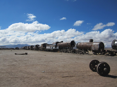
      The first thing we did on this tour was visit the train graveyard on the outskirts of town. Why? The first rail station in Bolivia was built in Uyuni. Why? Uyuni is surrounded by many mines: salt, gold, silver, copper, lithium. Foreign investors, who basically owned these mines, including the Bolivian president at the time (who was Spanish) decided to invest their money together to build the rail in order to transport the products of the mines more efficiently instead of using llamas and mules. It was a big deal for the country back in the early 1900s.


       One of the main reasons why Bolivia is so poor is because it is a landlocked country. Bolivia lost the coast to Chile in the War of the Pacific. Bolivians are still very bitter about this. Understandable. It´s not like Chile needed that northern bit of coast. The whole country of Chile IS coastline. In order to export its products, Bolivia has to cross the Chilean border and pay taxes there, then export off the Chilean coast where they pay more taxes.

       Recently, Bolivia has developed a close relationship with Venezuela because the current Bolivian president, Evo Morales, was close friends to the late Venezuelan president, Hugo Chavez. They were both socialistas and believers in creating a United South America. Today, to export goods Bolivia goes through Venezuela without taxes. Free trade. The U.S. government has its eye in Bolivian president Evo Morales because of his close relationship with the late Hugo Chavez.

      After checking out the skeletons of these retired trains, we drove to a small town, Colchani, where we learned about mining and processing salt. The salt miners (men) collect the salt from the Salar de Uyuni and bring it to town to be processed indoors (usually by women) where they dry and heat the salt to dehydrate it, then filter and grind this sal de gema (rock salt) and add iodine. Finally it is packaged. Mining salt is really hard on the body. If it can cause so much eroding damage to metals and cars, just imagine what it does to the human body. Our drivers were very meticulous about driving the cars through the salar. If the water is high (during rainy season) they cover the bottom of the cars and the engine with plastic tarp to protect them from salt damage. Even still, their Landcruisers are still replaced about every 5 years.

The final step: packaging the salt

       Next, we drove into the famous Salar de Uyuni. The salar is very thin around its edges, so the towns have built roads through these parts to access the salt flat. It is solid in its center. If you don´t find these roads to enter/exit the Salar, you risk sinking into the salty water and destroying your vehicle. The Salar lies over an ancient ¨extinct¨lake. 40,000 years ago it was a massive pre-historic, gaseous lake. The Pacific tectonic plate crashed under the South American plate, pushing up this volcanic and seismically active area into what is now the Andes, creating its high elevations, also causing lots of volcanic explosions encircling the area. The strength of the Andean sun caused the water to evaporate from this prehistoric lake and leave a thick salt crust. This ancient lake still exists deep under the Salar. It is 140m deep.The Salar is solid salt, though.

Piles of salt (sal de gema) for collecting

Hexagons

      The relationship between the expansion of frozen water during the freezing nights here and the evaporation of water under the daylight sun leaves behind a hexagonal lattice of salt on the flat. Like a white, flat beehive. The flats are so bright white you have to wear sunglasses. This is where we took our funny perspective photos.

 Evolution from a Pringles can

       In the middle of the Salar we went to one of the 32 islands, called Incahuasi, or as I remembered it, cactus island. The cacti on this island are ancient. They only grow 1 cm per year! The tall ones, therefore, are thousands of years old. We hiked around the short circuit trail of this island. At 4,000 m elevation I was huffing and puffing. How embarrassing. I didn´t expect to lose my Cusco lungs so soon. I guess I won´t be running a marathon when I get home after all.

Isla Incahuasi

      That night we arrived at our hotel. It was made of Salt! The bottom of the building was made of rocks (so that it wouldn´t disintegrate when it rained lol), but above the base of rocks, the rest of the building was made of salt bricks. All the furniture inside was also made of salt! Tables, chairs, beds (obviously not the mattresses)!
Salt hotel room

       After dinner, one of our guides gave us an interesting history/cultural lesson about Bolivia. He started by making fun of the early tourists who first came to the Salar de Uyuni with their high expectations from a 3rd world country that didn´t have any comforts from home to offer them. Tourism has grown exponentially in Uyuni and the tourist facilities have improved. The tourism is helping the small towns around the salar, too. Many tourists who go to Peru to do Machu Picchu also swing by Bolivia to see the salt flats. That´s a lot of tourists.

       Bolivia is rich with natural resources such as minerals, rainforest, and even OIL! In fact, gasoline prices in Bolivia are cheaper than anywhere else in South America because it has its own oil reserves and one refinery. Why the heck is Bolivia still a 3rd world country then? It has OIL for crying out loud! As previously  noted, Bolivia is landlocked, so that´s a problem. Secondly, Bolivia has experienced numerous dictatorships. The last one was during the late 1970s-1980s during the ¨Dirty War¨, aka the U.S. CIA´s Operation Condor. The president (Gonzalo Sánchez de Lozada) before current President Evo Morales was put into power through the support of the U.S. government. The Bolivian people overthrew and threatened to kill former President Lozada, and he is currently under refuge in the U.S. President Evo Morales was elected in 2007. He was an unlikely candidate because he was a coca farmer, he did not have any higher education, and he had been previously imprisoned. Despite all odds, he has turned this country around.

      Evo Morales is a socialist and the majority, especially the indigenous and the farmers, love him. Morales returned Bolivia to the hands of the people, its native people. By law there is no segregation between the classes. Big Cholita dress, or small dress, everyone has the right to go where they want. (Big Cholita dress, or native dress, was considered low class). Morales created a taxation system to fund education and health care for everyone, young and old, when there was no taxation in place before. He has turned Bolivia into a nationalistic country with the goal and efforts of being self-sufficient and sustainable. For example, Bolivia has oil. Oil is power (literally and figuratively). Enough at least to sustain itself. Another example is the mines only hire locals to work. La Paz has been transformed from a dirty poor city to a beautiful, clean, and business-flowing capital city. The question is: HOW did Morales find the money to do any of these things? What is the other side of the story? Where is the hidden corruption? Money doesn´t grow on trees.

      Morales was a coca farmer. He is currently the head of the Coca Farmers Association. It´s quite clear where his interests and support lie. He was previously imprisoned for trying to protect the coca farmers during Lozada´s presidency. Bolivia is infamous for its cocaine production (mind you, coca itself is NOT a drug. Coca is a widely used traditional plant and you need kilograms upon kilograms of coca leaves to make 1 gram of cocaine). I can only speculate that perhaps the money funneling into the government to support all of these social works is coming from cocaine. That´s just my guess. I don´t actually know. If this is the case, it raises the question: do the ends justify the means? In my opinion for Bolivia, my first impression is yes. The country and the people are so much better off than before.

      Like the other countries I have visited, Bolivia´s political system is modeled after that of the United States. The 2 political parties are the Socialistas and Sin Miedo (the conservative party). Next year is a re-election year and is supposed to be the end of Morales´s 2nd 4-year term.  Apparently he has recently succeeded in changing the number of presidential terms, so he can run for presidency again. Will this turn into a dictatorship-like presidency? We´ll see. However, the Sin Miedo campaigns have been on the rise, as the few wealthy people and other working groups (miners and other non-coca farmers) feel like they have been neglected by Morales. It will be an interesting election year.

      Back to our desert tour: we woke up on day 2 bright and early to questionable weather conditions that would determine where we could go and what we would see.

A semi-active volcano in the distance

One of the flamingo lagunas

Flamingos up close. Their down feathers underneath their big feathers keep
them insulated and able to live in the freezing conditions of the desert. Their
food is readily available. They eat the pink algae in the mud under the water.
That's what makes them so pink.

Arbol de Piedra (the Rock Tree)
 The highest elevation we reached: 4,800 m. Dry gusty wind
and snow. I was freezing and my lungs were hurting
walking around up here!

 Day 3 we saw more geological formations in the desert:

"The Lost City"


Valle de Piedras (Rock Valley)

The Canyon

Travel tips:
Red Planet tours for 3-day trip to Salar de Uyuni and desert
Hostal Piedra Blanca: book in advanced. 40-something bolivianos per night for dorm
Bus from Uyuni to La Paz: Omar bus 100 bolivianos